
Make a donation
Gear up for your next adventure:
As an Amazon Associate, this site earns from qualifying purchases at no extra cost to you.
Ambasamudram topographic map
Click on the map to display elevation.
Make a donation
Gear up for your next adventure:
As an Amazon Associate, this site earns from qualifying purchases at no extra cost to you.
Ambasamudram
Maancholai Hills is located between elevations ranging from 1,000 to 1,500 metres. The Maancholai area is deep within the Western Ghats, within the Kalakad Mundanthurai Tiger Reserve in the Tirunelveli District. Located on top of the Manimuthar Dam and the Manimuthar Water Falls, the Maancholai area comprises tea plantations, small settlements around the plantations; Upper Kodaiyar Dam and a windy view point called Kuthiravetti. Manimuttar Dam, Gadananathi River Dam, Rice Research Station of TNAU, Papanasam Dam, Karaiyar Dam, Singampatti Zamin palace, Servalar Dam, Kalakkad Mundanthurai Tiger Reserve, Agasthiyar Falls fed by lower dam., Baana Theertham Falls, Tamirabarani river, Sri Vedhanarayanar Rajagopalaswami Kulasekhara Azhwar Temple, Papanasaswamy Temple, Agashtiyar Temple, Krishnaswamy temple, kasi viswanathar temple and Durgai Amman Temple are the popular visitor attractions around the town.Also Papanasm , Agasthiyar falls which is around 5 Km from Ambasamudram.
Make a donation
Gear up for your next adventure:
As an Amazon Associate, this site earns from qualifying purchases at no extra cost to you.
About this map
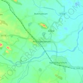
Name: Ambasamudram topographic map, elevation, terrain.
Location: Ambasamudram, Tirunelveli District, Tamil Nadu, 627400, India (8.66389 77.40755 8.74389 77.48755)
Average elevation: 233 ft
Minimum elevation: 167 ft
Maximum elevation: 482 ft
Make a donation
Gear up for your next adventure:
As an Amazon Associate, this site earns from qualifying purchases at no extra cost to you.
Other topographic maps
Click on a map to view its topography, its elevation and its terrain.
Kalakkad Mundanthurai Tiger Reserve
India > Tamil Nadu > Ambasamudram
The reserve spans a range of 40 to 1,800 m in elevation. Agasthiyamalai (1681 m.) is in the core zone of the reserve.
Average elevation: 1,296 ft