
Make a donation
Gear up for your next adventure:
As an Amazon Associate, this site earns from qualifying purchases at no extra cost to you.
Kamara topographic map
Click on the map to display elevation.
Make a donation
Gear up for your next adventure:
As an Amazon Associate, this site earns from qualifying purchases at no extra cost to you.
About this map
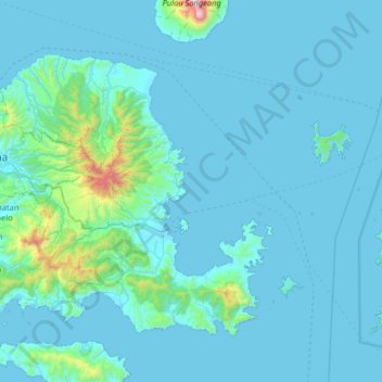
Name: Kamara topographic map, elevation, terrain.
Average elevation: 351 ft
Minimum elevation: 0 ft
Maximum elevation: 6,020 ft
Make a donation
Gear up for your next adventure:
As an Amazon Associate, this site earns from qualifying purchases at no extra cost to you.
Other topographic maps
Click on a map to view its topography, its elevation and its terrain.
Make a donation
Gear up for your next adventure:
As an Amazon Associate, this site earns from qualifying purchases at no extra cost to you.
REBAN BISOK BOKAH
Indonesia > West Nusa Tenggara > Lombok Tengah > Batas Desa Bebuak > Dusun Apit Aik
Average elevation: 1,312 ft
Make a donation
Gear up for your next adventure:
As an Amazon Associate, this site earns from qualifying purchases at no extra cost to you.
Sungai Pandan
Indonesia > West Nusa Tenggara > Lombok Tengah > Kecamatan Praya Barat Daya
Average elevation: 240 ft
Suntalangu Aik Ampat, Kelurahan Kelayu Jorong, Kecamatan Selong, Lombok Timur, NTB
Indonesia > West Nusa Tenggara
Average elevation: 220 ft
Dusun Pendem Selatan
Indonesia > West Nusa Tenggara > Lombok Tengah > Pendem
Average elevation: 1,073 ft
Batas Dusn montong Bulok
Indonesia > West Nusa Tenggara > Lombok Tengah > BATAS DESA MONTONG GAMANG
Average elevation: 1,122 ft
Make a donation
Gear up for your next adventure:
As an Amazon Associate, this site earns from qualifying purchases at no extra cost to you.
Make a donation
Gear up for your next adventure:
As an Amazon Associate, this site earns from qualifying purchases at no extra cost to you.