
Iquitos topographic map
Interactive map
Click on the map to display elevation.
About this map
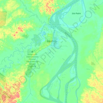
Name: Iquitos topographic map, elevation, terrain.
Location: Iquitos, Maynas, Loreto, Peru (-3.88645 -73.59096 -3.68525 -73.23643)
Average elevation: 308 ft
Minimum elevation: 256 ft
Maximum elevation: 479 ft
Other topographic maps
Click on a map to view its topography, its elevation and its terrain.
Nazaria
Peru > Loreto > Las Amazonas
Nazaria, Las Amazonas, Maynas, Loreto, Peru
Average elevation: 256 ft
Rio Itaya
Peru > Loreto > Belén > Nuevo Campeon
Rio Itaya, Belén, Nuevo Campeon, Belén, Maynas, Loreto, Peru
Average elevation: 295 ft
Copacabana
Copacabana, Morona, Datem del Marañón, Loreto, Peru
Average elevation: 449 ft
Santa Rosa de Yavari
Peru > Loreto > Santa Rosa de Yavari
Santa Rosa de Yavari, Mariscal Ramón Castilla, Loreto, Peru
Average elevation: 210 ft
Puerto Prado
Peru > Loreto > Puerto Prado
Puerto Prado, Ucayali, Loreto, Peru
Average elevation: 486 ft