
Thank you for supporting this site ❤️
Make a donation
Make a donation
Gear up for your next adventure:
As an Amazon Associate, this site earns from qualifying purchases at no extra cost to you.
Karanfiller topographic map
Click on the map to display elevation.
Thank you for supporting this site ❤️
Make a donation
Make a donation
Gear up for your next adventure:
As an Amazon Associate, this site earns from qualifying purchases at no extra cost to you.
About this map
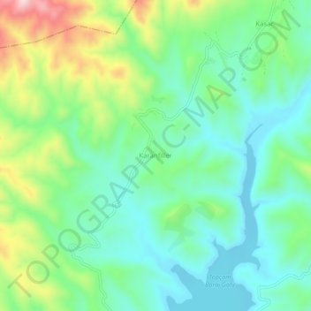
Name: Karanfiller topographic map, elevation, terrain.
Location: Karanfiller, Çine, Aydın, Aegean Region, Turkey (37.70526 27.98620 37.74526 28.02620)
Average elevation: 650 ft
Minimum elevation: 299 ft
Maximum elevation: 1,457 ft
Thank you for supporting this site ❤️
Make a donation
Make a donation
Gear up for your next adventure:
As an Amazon Associate, this site earns from qualifying purchases at no extra cost to you.