Geolocate

Antipuluan topographic map

Click on the map to display elevation.

About this map

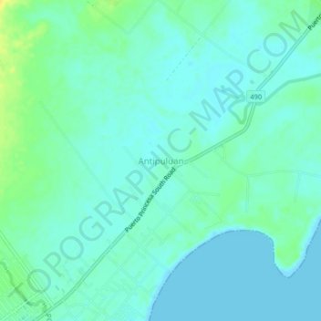
Name: Antipuluan topographic map, elevation, terrain.

Location: Antipuluan, Narra, Palawan, Mimaropa, 5303, Philippines (9.26962 118.40601 9.30962 118.44601)

Average elevation: 20 ft

Minimum elevation: 0 ft

Maximum elevation: 72 ft

Gear up for your next adventure:

🪶Trail Camera - Capture wildlife on your hikes
🪶Wildlife Field Guides - Learn animal tracking and species ID
🏕️Family Camping Gear - Essentials for group camping trips
🪶Paracord Bracelet - Survival bracelet with built‑in tools
⛑️Personal Locator Beacon - Safety beacon for emergencies

As an Amazon Associate, this site earns from qualifying purchases at no extra cost to you.