
Thank you for supporting this site ❤️
Make a donation
Make a donation
Gear up for your next adventure:
As an Amazon Associate, this site earns from qualifying purchases at no extra cost to you.
Pöllau topographic map
Click on the map to display elevation.
Thank you for supporting this site ❤️
Make a donation
Make a donation
Gear up for your next adventure:
As an Amazon Associate, this site earns from qualifying purchases at no extra cost to you.
About this map
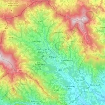
Name: Pöllau topographic map, elevation, terrain.
Location: Pöllau, Bezirk Hartberg-Fürstenfeld, Styria, 8225, Austria (47.24114 15.73414 47.37533 15.90472)
Average elevation: 2,277 ft
Minimum elevation: 1,086 ft
Maximum elevation: 4,167 ft
Thank you for supporting this site ❤️
Make a donation
Make a donation
Gear up for your next adventure:
As an Amazon Associate, this site earns from qualifying purchases at no extra cost to you.
Other topographic maps
Click on a map to view its topography, its elevation and its terrain.
Stubenberg am See
Austria > Styria > Bezirk Hartberg-Fürstenfeld > Stubenberg
Average elevation: 1,768 ft