Geolocate

Lampeter topographic map

Click on the map to display elevation.

About this map

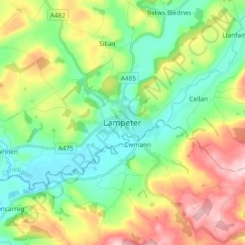
Name: Lampeter topographic map, elevation, terrain.

Location: Lampeter, Ceredigion, Wales, SA48 7DX, United Kingdom (52.07305 -4.11876 52.15305 -4.03876)

Average elevation: 646 ft

Minimum elevation: 341 ft

Maximum elevation: 1,204 ft

Other topographic maps

Click on a map to view its topography, its elevation and its terrain.

Penbryn

United Kingdom > Wales > Ceredigion

Average elevation: 377 ft

Gear up for your next adventure:

🎒Hydration Pack - Hands‑free water reservoir for long hikes
🥤Water Filter Bottle - All‑in‑one filter bottle for safe hydration
🌐World Map Poster - Decorative world maps with topographic info
🛏️Cold Weather Sleeping Bag - Warm sleeping bag for cold conditions
📶Vehicle Signal Boosters - Improve reception in rural areas while driving to trailheads

As an Amazon Associate, this site earns from qualifying purchases at no extra cost to you.