
Make a donation
Gear up for your next adventure:
As an Amazon Associate, this site earns from qualifying purchases at no extra cost to you.
Lugazi topographic map
Click on the map to display elevation.
Make a donation
Gear up for your next adventure:
As an Amazon Associate, this site earns from qualifying purchases at no extra cost to you.
Lugazi
The town is on the Kampala-Jinja Highway, approximately 46 kilometres (29 mi) east of Kampala, Uganda's capital and largest city. It is approximately 25.5 kilometres (16 mi), by road, east of Mukono, the nearest large town, also on the Kampala–Jinja Highway. Lugazi sits at an average elevation of 1,223 metres (4,012 ft), above mean sea level. The coordinates of Lugazi are 0°22'08.0"N, 32°56'25.0"E (Latitude:0.368889; Longitude:32.940278).
Make a donation
Gear up for your next adventure:
As an Amazon Associate, this site earns from qualifying purchases at no extra cost to you.
About this map
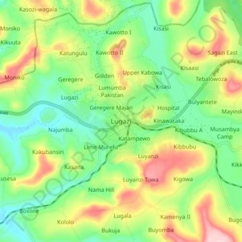
Name: Lugazi topographic map, elevation, terrain.
Location: Lugazi, Buikwe, Central Region, Uganda (0.32932 32.89674 0.40932 32.97674)
Average elevation: 3,976 ft
Minimum elevation: 3,694 ft
Maximum elevation: 4,423 ft
Make a donation
Gear up for your next adventure:
As an Amazon Associate, this site earns from qualifying purchases at no extra cost to you.