
Oberbronn topographic map
Interactive map
Click on the map to display elevation.
About this map
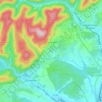
Name: Oberbronn topographic map, elevation, terrain.
Average elevation: 896 ft
Minimum elevation: 558 ft
Maximum elevation: 1,719 ft
Other topographic maps
Click on a map to view its topography, its elevation and its terrain.
Dambach-la-Ville
Dambach-la-Ville, Sélestat-Erstein, Bas-Rhin, Grand Est, France métropolitaine, 67650, France
Average elevation: 850 ft
Lichtenberg
Lichtenberg, Saverne, Bas-Rhin, Grand Est, France métropolitaine, 67340, France
Average elevation: 915 ft
Meistratzheim
Meistratzheim, Sélestat-Erstein, Bas-Rhin, Grand Est, France métropolitaine, 67210, France
Average elevation: 518 ft
Strasbourg
Strasbourg, Bas-Rhin, Grand Est, France métropolitaine, France
Average elevation: 472 ft
Stre.
France > Grand Est > Bas-Rhin > Oberlauterbach
Stre., Oberlauterbach, Haguenau-Wissembourg, Bas-Rhin, Grand Est, France métropolitaine, 67160, France
Average elevation: 561 ft
Orschwiller
Orschwiller, Sélestat-Erstein, Bas-Rhin, Grand Est, France métropolitaine, 67600, France
Average elevation: 889 ft
Engenthal
France > Grand Est > Bas-Rhin > Wangenbourg-Engenthal
Engenthal, Wangenbourg-Engenthal, Molsheim, Bas-Rhin, Grand Est, France métropolitaine, 67710, France
Average elevation: 1,739 ft
Dorlisheim
Dorlisheim, Molsheim, Bas-Rhin, Grand Est, France métropolitaine, 67120, France
Average elevation: 673 ft
Col du Donon
France > Grand Est > Bas-Rhin > Grandfontaine
Col du Donon, Haut Donon, Grandfontaine, Molsheim, Bas-Rhin, Grand Est, France métropolitaine, 67130, France
Average elevation: 2,277 ft
Obersteinbach
Obersteinbach, Haguenau-Wissembourg, Bas-Rhin, Grand Est, France métropolitaine, 67510, France
Average elevation: 1,056 ft
La Rothlach
France > Grand Est > Bas-Rhin > Le Hohwald
La Rothlach, Le Hohwald, Sélestat-Erstein, Bas-Rhin, Grand Est, France métropolitaine, 67140, France
Average elevation: 2,854 ft
Bouxwiller
France > Grand Est > Bas-Rhin > Bouxwiller
Bouxwiller, Saverne, Bas-Rhin, Grand Est, France métropolitaine, 67330, France
Average elevation: 732 ft
Le Hohwald
France > Grand Est > Bas-Rhin > Le Hohwald
Le Hohwald, Sélestat-Erstein, Bas-Rhin, Grand Est, France métropolitaine, 67140, France
Average elevation: 2,395 ft
Mittelhausbergen
France > Grand Est > Bas-Rhin > Mittelhausbergen
Mittelhausbergen, Strasbourg, Bas-Rhin, Grand Est, France métropolitaine, 67206, France
Average elevation: 518 ft
Mackenheim
France > Grand Est > Bas-Rhin > Mackenheim
Mackenheim, Sélestat-Erstein, Bas-Rhin, Grand Est, France métropolitaine, 67390, France
Average elevation: 571 ft
Muttersholtz
France > Grand Est > Bas-Rhin > Muttersholtz
Muttersholtz, Sélestat-Erstein, Bas-Rhin, Grand Est, France métropolitaine, 67600, France
Average elevation: 548 ft
Freudeneck
France > Grand Est > Bas-Rhin > Wangenbourg-Engenthal
Freudeneck, Wangenbourg-Engenthal, Molsheim, Bas-Rhin, Grand Est, France métropolitaine, 67710, France
Average elevation: 1,362 ft
Schœnbourg
France > Grand Est > Bas-Rhin > Schœnbourg
Schœnbourg, Saverne, Bas-Rhin, Grand Est, France métropolitaine, 67320, France
Average elevation: 994 ft
Breitenbach
Breitenbach, Sélestat-Erstein, Bas-Rhin, Grand Est, France métropolitaine, 67220, France
Average elevation: 1,995 ft
Saint-Pierre
Saint-Pierre, Sélestat-Erstein, Bas-Rhin, Grand Est, France métropolitaine, 67140, France
Average elevation: 604 ft
Preuschdorf
Preuschdorf, Haguenau-Wissembourg, Bas-Rhin, Grand Est, France métropolitaine, 67250, France
Average elevation: 768 ft
La Walck
France > Grand Est > Bas-Rhin > Val-de-Moder
La Walck, Val-de-Moder, Haguenau-Wissembourg, Bas-Rhin, Grand Est, France métropolitaine, 67350, France
Average elevation: 620 ft
Grandfontaine
Grandfontaine, Molsheim, Bas-Rhin, Grand Est, France métropolitaine, 67130, France
Average elevation: 2,001 ft
Natzwiller
Natzwiller, Molsheim, Bas-Rhin, Grand Est, France métropolitaine, 67130, France
Average elevation: 2,313 ft
Lauterbourg
Lauterbourg, Haguenau-Wissembourg, Bas-Rhin, Grand Est, France métropolitaine, 67630, France
Average elevation: 387 ft
La Petite-Pierre
La Petite-Pierre, Saverne, Bas-Rhin, Grand Est, France métropolitaine, 67290, France
Average elevation: 1,030 ft