
Grandfontaine topographic map
Interactive map
Click on the map to display elevation.
About this map
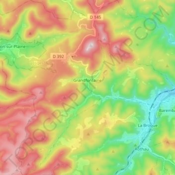
Name: Grandfontaine topographic map, elevation, terrain.
Average elevation: 2,001 ft
Minimum elevation: 968 ft
Maximum elevation: 3,248 ft
Grandfontaine est située à l'ouest du Bas-Rhin à la limite avec la Moselle. À 40 km de Molsheim et 5 km de Schirmeck, le village s'étire le long de différents ruisseaux (Framont, ruisseau des Minières, goutte Ferry, Grand Goutty) qui viennent alimenter la Bruche. Dans ce village de moyenne montagne, les habitations s'étagent de 400 à 700 mètres d'altitude et se concentrent dans le fond des vallons, le reste du territoire est occupée quasi exclusivement par la forêt. Quelques sommets environnants. le Donon (1 008 m), la Tête des Blanches Roches (916 m), la Corbeille (899 m), la Maxe (863 m), le Rond Perthuis (849 m), la Tête Mathis (838 m), le Haut de la Charaille (758 m). Un des points géodésiques du réseau géodésique français se trouve dans la commune, à proximité du col du Donon. Il constitue même l'un des vingt-trois points du Réseau de référence français.
Other topographic maps
Click on a map to view its topography, its elevation and its terrain.
Dambach-la-Ville
Dambach-la-Ville, Sélestat-Erstein, Bas-Rhin, Grand Est, France métropolitaine, 67650, France
Average elevation: 850 ft
Lichtenberg
Lichtenberg, Saverne, Bas-Rhin, Grand Est, France métropolitaine, 67340, France
Average elevation: 915 ft
Meistratzheim
Meistratzheim, Sélestat-Erstein, Bas-Rhin, Grand Est, France métropolitaine, 67210, France
Average elevation: 518 ft
Strasbourg
Strasbourg, Bas-Rhin, Grand Est, France métropolitaine, France
Average elevation: 472 ft
Stre.
France > Grand Est > Bas-Rhin > Oberlauterbach
Stre., Oberlauterbach, Haguenau-Wissembourg, Bas-Rhin, Grand Est, France métropolitaine, 67160, France
Average elevation: 561 ft
Orschwiller
Orschwiller, Sélestat-Erstein, Bas-Rhin, Grand Est, France métropolitaine, 67600, France
Average elevation: 889 ft
Engenthal
France > Grand Est > Bas-Rhin > Wangenbourg-Engenthal
Engenthal, Wangenbourg-Engenthal, Molsheim, Bas-Rhin, Grand Est, France métropolitaine, 67710, France
Average elevation: 1,739 ft
Dorlisheim
Dorlisheim, Molsheim, Bas-Rhin, Grand Est, France métropolitaine, 67120, France
Average elevation: 673 ft
Col du Donon
France > Grand Est > Bas-Rhin > Grandfontaine
Col du Donon, Haut Donon, Grandfontaine, Molsheim, Bas-Rhin, Grand Est, France métropolitaine, 67130, France
Average elevation: 2,277 ft
Obersteinbach
Obersteinbach, Haguenau-Wissembourg, Bas-Rhin, Grand Est, France métropolitaine, 67510, France
Average elevation: 1,056 ft
La Rothlach
France > Grand Est > Bas-Rhin > Le Hohwald
La Rothlach, Le Hohwald, Sélestat-Erstein, Bas-Rhin, Grand Est, France métropolitaine, 67140, France
Average elevation: 2,854 ft
Bouxwiller
France > Grand Est > Bas-Rhin > Bouxwiller
Bouxwiller, Saverne, Bas-Rhin, Grand Est, France métropolitaine, 67330, France
Average elevation: 732 ft
Le Hohwald
France > Grand Est > Bas-Rhin > Le Hohwald
Le Hohwald, Sélestat-Erstein, Bas-Rhin, Grand Est, France métropolitaine, 67140, France
Average elevation: 2,395 ft
Mittelhausbergen
France > Grand Est > Bas-Rhin > Mittelhausbergen
Mittelhausbergen, Strasbourg, Bas-Rhin, Grand Est, France métropolitaine, 67206, France
Average elevation: 518 ft
Mackenheim
France > Grand Est > Bas-Rhin > Mackenheim
Mackenheim, Sélestat-Erstein, Bas-Rhin, Grand Est, France métropolitaine, 67390, France
Average elevation: 571 ft
Muttersholtz
France > Grand Est > Bas-Rhin > Muttersholtz
Muttersholtz, Sélestat-Erstein, Bas-Rhin, Grand Est, France métropolitaine, 67600, France
Average elevation: 548 ft
Freudeneck
France > Grand Est > Bas-Rhin > Wangenbourg-Engenthal
Freudeneck, Wangenbourg-Engenthal, Molsheim, Bas-Rhin, Grand Est, France métropolitaine, 67710, France
Average elevation: 1,362 ft
Schœnbourg
France > Grand Est > Bas-Rhin > Schœnbourg
Schœnbourg, Saverne, Bas-Rhin, Grand Est, France métropolitaine, 67320, France
Average elevation: 994 ft
Breitenbach
Breitenbach, Sélestat-Erstein, Bas-Rhin, Grand Est, France métropolitaine, 67220, France
Average elevation: 1,995 ft
Saint-Pierre
Saint-Pierre, Sélestat-Erstein, Bas-Rhin, Grand Est, France métropolitaine, 67140, France
Average elevation: 604 ft
Preuschdorf
Preuschdorf, Haguenau-Wissembourg, Bas-Rhin, Grand Est, France métropolitaine, 67250, France
Average elevation: 768 ft
La Walck
France > Grand Est > Bas-Rhin > Val-de-Moder
La Walck, Val-de-Moder, Haguenau-Wissembourg, Bas-Rhin, Grand Est, France métropolitaine, 67350, France
Average elevation: 620 ft
Natzwiller
Natzwiller, Molsheim, Bas-Rhin, Grand Est, France métropolitaine, 67130, France
Average elevation: 2,313 ft
Lauterbourg
Lauterbourg, Haguenau-Wissembourg, Bas-Rhin, Grand Est, France métropolitaine, 67630, France
Average elevation: 387 ft
La Petite-Pierre
La Petite-Pierre, Saverne, Bas-Rhin, Grand Est, France métropolitaine, 67290, France
Average elevation: 1,030 ft