
Make a donation
Gear up for your next adventure:
As an Amazon Associate, this site earns from qualifying purchases at no extra cost to you.
Martenslinde topographic map
Click on the map to display elevation.
Make a donation
Gear up for your next adventure:
As an Amazon Associate, this site earns from qualifying purchases at no extra cost to you.
Martenslinde
Martenslinde ligt in Vochtig-Haspengouw, en heeft een hoogte die varieert van 77 tot 110 meter. De Wilderbeek stroomt vlak langs het dorp. In de vallei daarvan bevindt zich het Wilderpark, een natuurgebied dat zich ten noorden van het dorp uitstrekt. Op het plateau wordt landbouw en fruitteelt beoefend.
Make a donation
Gear up for your next adventure:
As an Amazon Associate, this site earns from qualifying purchases at no extra cost to you.
About this map
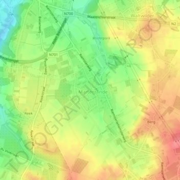
Name: Martenslinde topographic map, elevation, terrain.
Average elevation: 292 ft
Minimum elevation: 167 ft
Maximum elevation: 397 ft
Make a donation
Gear up for your next adventure:
As an Amazon Associate, this site earns from qualifying purchases at no extra cost to you.