Geolocate

Plauen topographic map

Click on the map to display elevation.

About this map
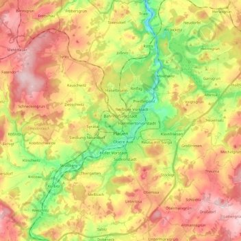
Name: Plauen topographic map, elevation, terrain.

Location: Plauen, Vogtlandkreis, Saxony, Germany (50.43067 12.05966 50.57489 12.22945)

Average elevation: 1,407 ft

Minimum elevation: 984 ft

Maximum elevation: 1,814 ft

Other topographic maps

Click on a map to view its topography, its elevation and its terrain.

Gippe

Germany > Saxony > Vogtlandkreis > Elsterberg

Average elevation: 1,175 ft

Mühlleithen

Germany > Saxony > Vogtlandkreis > Klingenthal

Average elevation: 2,707 ft

Röthenbach

Germany > Saxony > Vogtlandkreis > Bad Brambach > Hohendorf

Average elevation: 2,103 ft

Gear up for your next adventure:

🧤Hiking Gloves - Protective gloves for rugged trails
🎒Waterproof Dry Bags - Keep your electronics and maps dry inside your pack
💧Water Purification System - Clean water on the trail with reliable purifiers
📶Vehicle Signal Boosters - Improve reception in rural areas while driving to trailheads
❄️Traction Cleats - Prevent slips on icy trails during winter hikes

As an Amazon Associate, this site earns from qualifying purchases at no extra cost to you.