
Roma topographic map
Click on the map to display elevation.
About this map
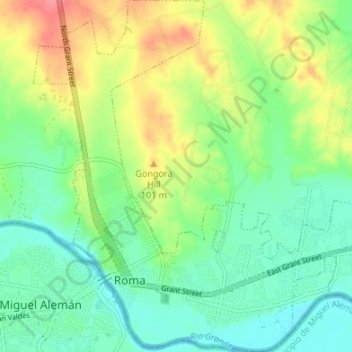
Name: Roma topographic map, elevation, terrain.
Location: Roma, Starr County, Texas, United States (26.39156 -99.03280 26.45167 -98.96979)
Average elevation: 240 ft
Minimum elevation: 151 ft
Maximum elevation: 397 ft
Starr County trails, hiking, mountain biking, running and outdoor activities
Other topographic maps
Click on a map to view its topography, its elevation and its terrain.
Lower Rio Grande Valley National Wildlife Refuge
United States > Texas > Starr County > Rio Grande City
Average elevation: 164 ft
Rio Grande City
United States > Texas > Starr County > Rio Grande City > Rio Grande City
Average elevation: 197 ft
Garza-Gutierrez Colonia
United States > Texas > Starr County > Rio Grande City > Garza-Gutierrez Colonia
Average elevation: 194 ft