
Make a donation
Gear up for your next adventure:
As an Amazon Associate, this site earns from qualifying purchases at no extra cost to you.
Falcon Heights topographic map
Click on the map to display elevation.
Make a donation
Gear up for your next adventure:
As an Amazon Associate, this site earns from qualifying purchases at no extra cost to you.
About this map
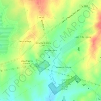
Name: Falcon Heights topographic map, elevation, terrain.
Location: Falcon Heights, Starr County, Texas, 78585, United States (26.53881 -99.14280 26.57881 -99.10280)
Average elevation: 305 ft
Minimum elevation: 220 ft
Maximum elevation: 407 ft
Starr County trails, hiking, mountain biking, running and outdoor activities
Make a donation
Gear up for your next adventure:
As an Amazon Associate, this site earns from qualifying purchases at no extra cost to you.
Other topographic maps
Click on a map to view its topography, its elevation and its terrain.
Lower Rio Grande Valley National Wildlife Refuge
United States > Texas > Starr County > Rio Grande City
Average elevation: 164 ft
Make a donation
Gear up for your next adventure:
As an Amazon Associate, this site earns from qualifying purchases at no extra cost to you.
Make a donation
Gear up for your next adventure:
As an Amazon Associate, this site earns from qualifying purchases at no extra cost to you.