Geolocate

Mel topographic map

Click on the map to display elevation.

About this map

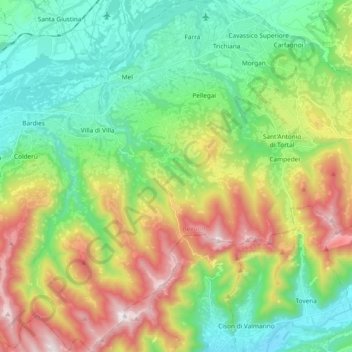
Name: Mel topographic map, elevation, terrain.

Location: Mel, Borgo Valbelluna, Belluno, Veneto, 32026, Italy (45.96021 12.02585 46.09083 12.16974)

Average elevation: 1,962 ft

Minimum elevation: 669 ft

Maximum elevation: 4,455 ft

Gear up for your next adventure:

🧴Hand Sanitizer - Keep hands clean while hiking
🪶LED Camping Lantern - Bright lantern for camp lighting
⛑️Personal Locator Beacon - Safety beacon for emergencies
🥾Hiking Shoes - Durable and comfortable shoes for trail hiking
🦶Hiking Gaiters - Keep debris and water out of your boots

As an Amazon Associate, this site earns from qualifying purchases at no extra cost to you.