
Make a donation
Gear up for your next adventure:
As an Amazon Associate, this site earns from qualifying purchases at no extra cost to you.
Achenmühle topographic map
Click on the map to display elevation.
Make a donation
Gear up for your next adventure:
As an Amazon Associate, this site earns from qualifying purchases at no extra cost to you.
About this map
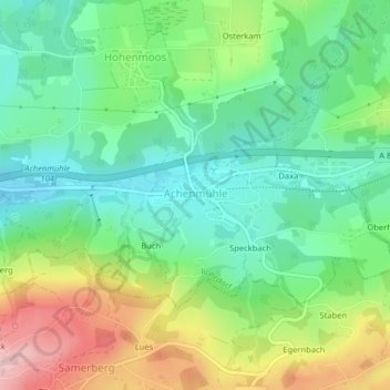
Name: Achenmühle topographic map, elevation, terrain.
Location: Achenmühle, Rohrdorf, Landkreis Rosenheim, Bayern, Deutschland (47.79264 12.22342 47.79781 12.23556)
Average elevation: 1,942 ft
Minimum elevation: 1,663 ft
Maximum elevation: 2,457 ft
Make a donation
Gear up for your next adventure:
As an Amazon Associate, this site earns from qualifying purchases at no extra cost to you.
Other topographic maps
Click on a map to view its topography, its elevation and its terrain.
Hohenaschau
Deutschland > Bayern > Landkreis Rosenheim > Aschau im Chiemgau
Aschach | Aschau im Chiemgau | Attich | Aufham | Außerkoy | Außerwald | Bach | Berg | Brückl | Bucha | Einfang | Engerndorf | Fellerer | Göttersberg | Grattenbach | Grenzhub | Grünwald | Hainbach | Haindorf | Hammerbach | Hintergschwendt | Hohenaschau im Chiemgau | Höhenberg | Hub | Huben | Innerkoy |…
Average elevation: 2,831 ft
Make a donation
Gear up for your next adventure:
As an Amazon Associate, this site earns from qualifying purchases at no extra cost to you.