Geolocate

Kester topographic map

Click on the map to display elevation.

About this map

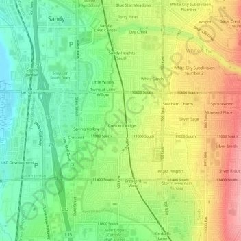
Name: Kester topographic map, elevation, terrain.

Location: Kester, Sandy, Salt Lake County, Utah, 84070, United States (40.53412 -111.90132 40.57412 -111.86132)

Average elevation: 4,495 ft

Minimum elevation: 4,308 ft

Maximum elevation: 4,738 ft

Salt Lake County trails, hiking, mountain biking, running and outdoor activities

Other topographic maps

Click on a map to view its topography, its elevation and its terrain.

Granite Park

United States > Utah > Salt Lake County > Sandy > Granite Crest

Average elevation: 5,033 ft

Gear up for your next adventure:

🏕️Tent Footprint - Protect your tent base from wear
🔋Rechargeable Batteries - Power up your outdoor devices
📷Action Cameras - Rugged cameras to document your journeys across rugged terrain
🛰️Satellite Messengers - Emergency SOS and two-way messaging for off-grid adventures
🧢Sun Protection Hats - Wide-brimmed and UPF-rated hats for high-altitude sun safety

As an Amazon Associate, this site earns from qualifying purchases at no extra cost to you.