
Make a donation
Gear up for your next adventure:
As an Amazon Associate, this site earns from qualifying purchases at no extra cost to you.
Cigombong topographic map
Click on the map to display elevation.
Make a donation
Gear up for your next adventure:
As an Amazon Associate, this site earns from qualifying purchases at no extra cost to you.
About this map
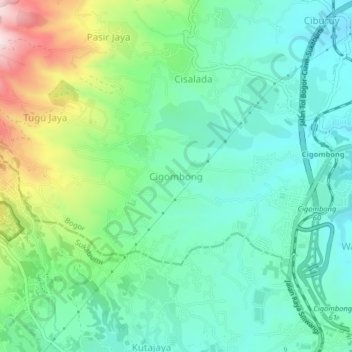
Name: Cigombong topographic map, elevation, terrain.
Location: Cigombong, Bogor, West Java, 16110, Indonesia (-6.76588 106.76607 -6.72588 106.80607)
Average elevation: 1,893 ft
Minimum elevation: 1,512 ft
Maximum elevation: 2,867 ft
Make a donation
Gear up for your next adventure:
As an Amazon Associate, this site earns from qualifying purchases at no extra cost to you.
Other topographic maps
Click on a map to view its topography, its elevation and its terrain.
Cisarua
Cisarua is a location and district in the Bogor Regency, located in the province of West Java, with a population of 127,096 in 2020.[1] The district is known for its mild climate, tea fields, and extensive views, being located in a rather high altitude.[citation needed]
Average elevation: 4,298 ft