Geolocate

Denoman topographic map

Click on the map to display elevation.

About this map

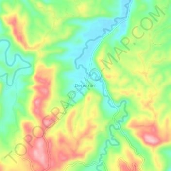
Name: Denoman topographic map, elevation, terrain.

Location: Denoman, Zamboanga del Norte, Zamboanga Peninsula, Philippines (8.45798 123.19572 8.49798 123.23572)

Average elevation: 308 ft

Minimum elevation: 39 ft

Maximum elevation: 656 ft

Other topographic maps

Click on a map to view its topography, its elevation and its terrain.

Sibuco

Philippines > Zamboanga del Norte

Average elevation: 581 ft

Sibuco

Philippines > Zamboanga del Norte

Average elevation: 581 ft

Dapitan River

Philippines > Zamboanga del Norte

Average elevation: 961 ft

Gear up for your next adventure:

🔋Solar Power Banks - Keep your GPS and phone charged in remote wilderness areas
🧣Hiking Neck Gaiter - Multi‑use neck protection for outdoor weather
🥤Water Filter Bottle - All‑in‑one filter bottle for safe hydration
🧭Pro Hiking Compasses - High-accuracy liquid-filled compasses for topographic orientation
🌐World Map Poster - Decorative world maps with topographic info

As an Amazon Associate, this site earns from qualifying purchases at no extra cost to you.