
Make a donation
Gear up for your next adventure:
As an Amazon Associate, this site earns from qualifying purchases at no extra cost to you.
Abernathy Creek topographic map
Click on the map to display elevation.
Make a donation
Gear up for your next adventure:
As an Amazon Associate, this site earns from qualifying purchases at no extra cost to you.
About this map
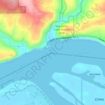
Name: Abernathy Creek topographic map, elevation, terrain.
Location: Abernathy Creek, Columbia County, Oregon, United States (46.18773 -123.16746 46.19057 -123.16596)
Average elevation: 125 ft
Minimum elevation: -7 ft
Maximum elevation: 525 ft
Columbia County trails, hiking, mountain biking, running and outdoor activities
Make a donation
Gear up for your next adventure:
As an Amazon Associate, this site earns from qualifying purchases at no extra cost to you.
Other topographic maps
Click on a map to view its topography, its elevation and its terrain.
Pittsburg
United States > Oregon > Columbia County
Pittsburg is an unincorporated community in Columbia County, Oregon, United States. Pittsburg is located on the Nehalem River near its confluence with the East Fork Nehalem River. The Scappoose-Vernonia road and the St. Helens-Pittsburg road join Oregon Route 47 near Pittsburg. Pittsburg's elevation is 584…
Average elevation: 764 ft
Make a donation
Gear up for your next adventure:
As an Amazon Associate, this site earns from qualifying purchases at no extra cost to you.