Geolocate

Ermington topographic map

Click on the map to display elevation.

About this map

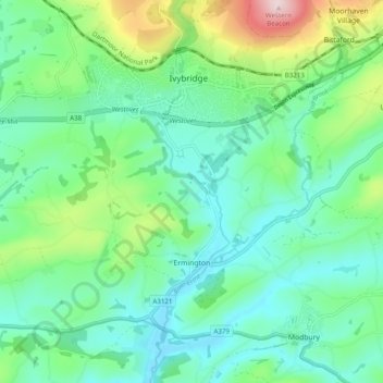
Name: Ermington topographic map, elevation, terrain.

Location: Ermington, South Hams, Devon, England, United Kingdom (50.35038 -3.97359 50.39600 -3.87544)

Average elevation: 279 ft

Minimum elevation: 10 ft

Maximum elevation: 1,086 ft

Other topographic maps

Click on a map to view its topography, its elevation and its terrain.

Penquit

United Kingdom > England > Devon > South Hams > Ermington

Average elevation: 217 ft

Weston

United Kingdom > England > Devon > South Hams > Berry Pomeroy

Average elevation: 194 ft

Gear up for your next adventure:

🧭Orienteering Set - Complete compass and map reading kit
🩹Survival Bandages - High‑quality bandages for emergencies
🌄Hiking Binoculars - Compact binoculars for scenic views and trail spotting
🚪Portable Camp Chair - Foldable chair for comfort at camp
🍳Camping Cook Set - Complete cookware for outdoor meals

As an Amazon Associate, this site earns from qualifying purchases at no extra cost to you.