
Make a donation
Gear up for your next adventure:
As an Amazon Associate, this site earns from qualifying purchases at no extra cost to you.
Marsala topographic map
Click on the map to display elevation.
Make a donation
Gear up for your next adventure:
As an Amazon Associate, this site earns from qualifying purchases at no extra cost to you.
Marsala
The archaeological area of Marsala has been investigated both through excavations and topographic studies. Lilybaeum, the ancient town, took up a rectangular area on Capo Boeo, a low and rocky promontory sloping gently down towards the sea. The urban layout of the town can be dated back to the 2nd century BC with modern-day Viale Vittorio Veneto the Decumanus Maximus and Viale Cesare Battisti the Cardo Maximus.
Make a donation
Gear up for your next adventure:
As an Amazon Associate, this site earns from qualifying purchases at no extra cost to you.
About this map
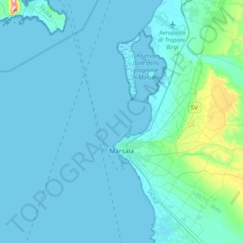
Name: Marsala topographic map, elevation, terrain.
Location: Marsala, Trapani, Sicily, 91025, Italy (37.71391 12.42425 37.93445 12.69461)
Average elevation: 72 ft
Minimum elevation: -7 ft
Maximum elevation: 951 ft
Make a donation
Gear up for your next adventure:
As an Amazon Associate, this site earns from qualifying purchases at no extra cost to you.
Other topographic maps
Click on a map to view its topography, its elevation and its terrain.
Make a donation
Gear up for your next adventure:
As an Amazon Associate, this site earns from qualifying purchases at no extra cost to you.
Make a donation
Gear up for your next adventure:
As an Amazon Associate, this site earns from qualifying purchases at no extra cost to you.