
Make a donation
Gear up for your next adventure:
As an Amazon Associate, this site earns from qualifying purchases at no extra cost to you.
Macari topographic map
Click on the map to display elevation.
Make a donation
Gear up for your next adventure:
As an Amazon Associate, this site earns from qualifying purchases at no extra cost to you.
About this map
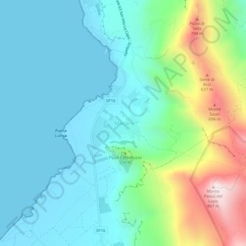
Name: Macari topographic map, elevation, terrain.
Location: Macari, San Vito Lo Capo, Trapani, Sicily, 91030, Italy (38.11197 12.72150 38.15197 12.76150)
Average elevation: 738 ft
Minimum elevation: -3 ft
Maximum elevation: 2,792 ft
Make a donation
Gear up for your next adventure:
As an Amazon Associate, this site earns from qualifying purchases at no extra cost to you.
Other topographic maps
Click on a map to view its topography, its elevation and its terrain.
Make a donation
Gear up for your next adventure:
As an Amazon Associate, this site earns from qualifying purchases at no extra cost to you.
Marsala
The archaeological area of Marsala has been investigated both through excavations and topographic studies. Lilybaeum, the ancient town, took up a rectangular area on Capo Boeo, a low and rocky promontory sloping gently down towards the sea. The urban layout of the town can be dated back to the 2nd century BC…
Average elevation: 72 ft
Trapani
Much of the built-up peninsula is very low-lying, with the city’s average elevation around 3 m above sea level. To the north a strip of sandy beach runs below the Mura di Tramontana at the edge of the historic centre, while to the south the urban area gives way to the low-lying salt-pans and wetlands of the…
Average elevation: 184 ft
Make a donation
Gear up for your next adventure:
As an Amazon Associate, this site earns from qualifying purchases at no extra cost to you.
Alcamo
Alcamo is situated in the middle of the Gulf of Castellammare, at 258 metres above the sea level and at the foot of Mount Bonifato, a calcareous complex 825 metres high. At the altitude of 500 metres (near the "Funtanazza") there is the Nature Reserve of Monte Bonifato.
Average elevation: 633 ft
Marsala
The archaeological area of Marsala has been investigated both through excavations and topographic studies. Lilybaeum, the ancient town, took up a rectangular area on Capo Boeo, a low and rocky promontory sloping gently down towards the sea. The urban layout of the town can be dated back to the 2nd century BC…
Average elevation: 72 ft
Make a donation
Gear up for your next adventure:
As an Amazon Associate, this site earns from qualifying purchases at no extra cost to you.
Trapani
Much of the built-up peninsula is very low-lying, with the city’s average elevation around 3 m above sea level. To the north a strip of sandy beach runs below the Mura di Tramontana at the edge of the historic centre, while to the south the urban area gives way to the low-lying salt-pans and wetlands of the…
Average elevation: 184 ft
Make a donation
Gear up for your next adventure:
As an Amazon Associate, this site earns from qualifying purchases at no extra cost to you.
Make a donation
Gear up for your next adventure:
As an Amazon Associate, this site earns from qualifying purchases at no extra cost to you.