
Songadh topographic map
Click on the map to display elevation.
Songadh
Fort Songadh is located at 21°10′N 73°34′E / 21.17°N 73.57°E / 21.17; 73.57. It has an average elevation of 112 metres (367 feet).
About this map
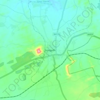
Name: Songadh topographic map, elevation, terrain.
Location: Songadh, Songadh Taluka, Tapi District, Gujarat, 394670, India (21.13021 73.52229 21.21021 73.60229)
Average elevation: 407 ft
Minimum elevation: 246 ft
Maximum elevation: 1,040 ft