
Franklin Township topographic map
Interactive map
Click on the map to display elevation.
About this map
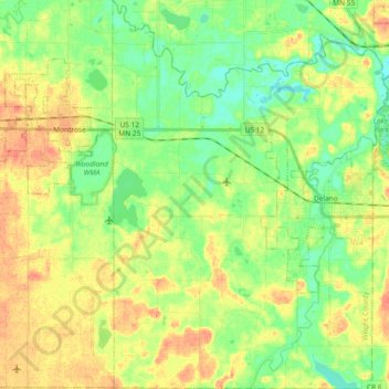
Name: Franklin Township topographic map, elevation, terrain.
Location: Franklin Township, Wright County, Minnesota, United States (44.97767 -93.89086 45.10833 -93.75858)
Average elevation: 951 ft
Minimum elevation: 889 ft
Maximum elevation: 1,024 ft
Other topographic maps
Click on a map to view its topography, its elevation and its terrain.
Chatham Township
United States > Minnesota > Wright County
Chatham Township, Wright County, Minnesota, United States
Average elevation: 991 ft