
Hof topographic map
Click on the map to display elevation.
Hof
Das Gebiet der Stadt Hof liegt beiderseits der Grenze zwischen dem Mittelvogtländischen Kuppenland (Teil des Vogtlandes, im Nordosten) und der Münchberger Hochfläche (Teil des Thüringisch-Fränkischen Mittelgebirges, im Südwesten). Die Stadt Hof liegt im Flusstal der Saale, die das Stadtgebiet zwischen Fichtelgebirge und Frankenwald auf dem südlichen Rand des Mittelvogtländischen Kuppenlandes von Süden nach Norden durchfließt. In Hof gibt es 17 Saalebrücken. Bedingt durch die Mittelgebirgslage sind die Abhänge des Flusstales verhältnismäßig steil. Der tiefste Punkt von Hof liegt an der Saale bei etwa 450 Höhenmetern, der höchste Punkt im Stadtgebiet am Kulm bei 614 m Höhe. Dadurch hat die Stadt vor allem in Ost-West-Richtung Straßen mit erheblichen Steigungen.
About this map
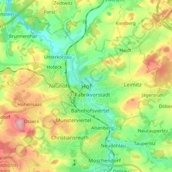
Name: Hof topographic map, elevation, terrain.
Location: Hof, Oberfranken, Bayern, 95028, Deutschland (50.28190 11.87788 50.36190 11.95788)
Average elevation: 1,716 ft
Minimum elevation: 1,506 ft
Maximum elevation: 2,057 ft
Other topographic maps
Click on a map to view its topography, its elevation and its terrain.