Geolocate

Jennings topographic map

Click on the map to display elevation.

About this map

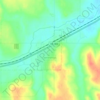
Name: Jennings topographic map, elevation, terrain.

Location: Jennings, Decatur County, Kansas, 67643, United States (39.67597 -100.29789 39.68678 -100.28938)

Average elevation: 2,523 ft

Minimum elevation: 2,464 ft

Maximum elevation: 2,618 ft

Decatur County trails, hiking, mountain biking, running and outdoor activities

Other topographic maps

Click on a map to view its topography, its elevation and its terrain.

Cedar Bluffs

United States > Kansas > Decatur County

Average elevation: 2,605 ft

Leoville

United States > Kansas > Decatur County

Average elevation: 2,762 ft

Gear up for your next adventure:

🗺️NatGeo Topo Maps - High-quality waterproof printed topographic maps of US Parks
🍳Camping Cook Set - Complete cookware for outdoor meals
🧭Pro Hiking Compasses - High-accuracy liquid-filled compasses for topographic orientation
🧣Merino Neck Gaiters - Multi-functional headwear for wind and sun protection
🔥Plasma Lighters - Windproof lighters that work in any weather condition

As an Amazon Associate, this site earns from qualifying purchases at no extra cost to you.