
Make a donation
Gear up for your next adventure:
As an Amazon Associate, this site earns from qualifying purchases at no extra cost to you.
Ngqushwa Local Municipality topographic map
Click on the map to display elevation.
Make a donation
Gear up for your next adventure:
As an Amazon Associate, this site earns from qualifying purchases at no extra cost to you.
About this map
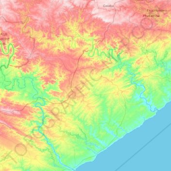
Name: Ngqushwa Local Municipality topographic map, elevation, terrain.
Average elevation: 761 ft
Minimum elevation: -7 ft
Maximum elevation: 2,034 ft
Make a donation
Gear up for your next adventure:
As an Amazon Associate, this site earns from qualifying purchases at no extra cost to you.
Other topographic maps
Click on a map to view its topography, its elevation and its terrain.
Marshstrand
South Africa > Eastern Cape > Amathole District Municipality > Great Kei Local Municipality
Average elevation: 121 ft
Cathcart
South Africa > Eastern Cape > Amathole District Municipality > Amahlathi Local Municipality
Average elevation: 3,924 ft
Gcuwa River
South Africa > Eastern Cape > Amathole District Municipality > Mnquma Local Municipality > Butterworth
Average elevation: 1,854 ft
Bedford
South Africa > Eastern Cape > Amathole District Municipality > Nxuba Local Municipality
Average elevation: 2,789 ft
Make a donation
Gear up for your next adventure:
As an Amazon Associate, this site earns from qualifying purchases at no extra cost to you.
Keiskammahoek
South Africa > Eastern Cape > Amathole District Municipality > Amahlathi Local Municipality
Average elevation: 2,195 ft
Mbiza
South Africa > Eastern Cape > Amathole District Municipality > Mnquma Local Municipality
Average elevation: 2,477 ft
Chintsa
South Africa > Eastern Cape > Amathole District Municipality > Great Kei Local Municipality
Average elevation: 144 ft
Kubusi River
South Africa > Eastern Cape > Amathole District Municipality > Amahlathi Local Municipality
Average elevation: 2,621 ft
Make a donation
Gear up for your next adventure:
As an Amazon Associate, this site earns from qualifying purchases at no extra cost to you.
Cumakala
South Africa > Eastern Cape > Amathole District Municipality > Amahlathi Local Municipality > Cumakala
Average elevation: 2,743 ft
Ngqatyana
South Africa > Eastern Cape > Amathole District Municipality > Mbhashe Local Municipality
Average elevation: 879 ft
Ntaba kaNdoda Peak
South Africa > Eastern Cape > Amathole District Municipality > Amahlathi Local Municipality
Average elevation: 2,451 ft
Kat River
South Africa > Eastern Cape > Amathole District Municipality > Nkonkobe Local Municipality
Average elevation: 1,070 ft
Make a donation
Gear up for your next adventure:
As an Amazon Associate, this site earns from qualifying purchases at no extra cost to you.