
Make a donation
Gear up for your next adventure:
As an Amazon Associate, this site earns from qualifying purchases at no extra cost to you.
Ammersee topographic map
Click on the map to display elevation.
Make a donation
Gear up for your next adventure:
As an Amazon Associate, this site earns from qualifying purchases at no extra cost to you.
Ammersee
Der Wasserspiegel des Ammersees lag entgegen verbreiteter Darstellung in der älteren Literatur niemals signifikant höher als heute. Das Durchbruchstal von Grafrath-Wildenroth wurde schon beim Abschmelzen des Gletschereises gebildet, wie die durch Schmelzwasser gebildeten kiesigen Eisrandterrassen an beiden Seiten des Ammersees und des Ampermooses belegen.
Make a donation
Gear up for your next adventure:
As an Amazon Associate, this site earns from qualifying purchases at no extra cost to you.
About this map
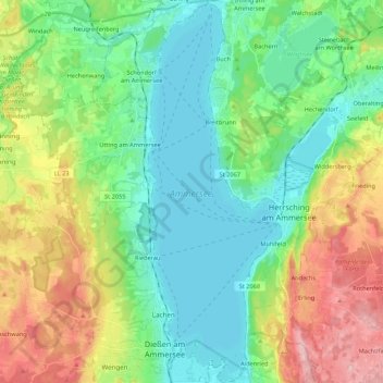
Name: Ammersee topographic map, elevation, terrain.
Location: Ammersee, Landkreis Landsberg am Lech, Bayern, Deutschland (47.93504 11.09547 48.07887 11.17072)
Average elevation: 1,955 ft
Minimum elevation: 1,739 ft
Maximum elevation: 2,425 ft
Make a donation
Gear up for your next adventure:
As an Amazon Associate, this site earns from qualifying purchases at no extra cost to you.
Other topographic maps
Click on a map to view its topography, its elevation and its terrain.
Geretshausen
Deutschland > Bayern > Landkreis Landsberg am Lech
Das Pfarrdorf liegt etwa eineinhalb Kilometer ostsüdöstlich der Ortsmitte von Weil auf einer Höhe von 591 m ü. NHN. Naturräumlich befindet es sich im Lechrain am östlichen Hochufer des Verlorenen Baches, dem dort auch der Sägmühlbach und der Dorfgraben zufließen.
Average elevation: 1,929 ft
Make a donation
Gear up for your next adventure:
As an Amazon Associate, this site earns from qualifying purchases at no extra cost to you.
Dettenschwang
Deutschland > Bayern > Landkreis Landsberg am Lech > Dießen am Ammersee
Das Pfarrdorf Dettenschwang liegt circa sechs Kilometer westlich von Dießen am Ammersee auf einem Höhenrücken in einer eiszeitlichen Jungmoränenlandschaft.
Average elevation: 2,215 ft
Make a donation
Gear up for your next adventure:
As an Amazon Associate, this site earns from qualifying purchases at no extra cost to you.
Make a donation
Gear up for your next adventure:
As an Amazon Associate, this site earns from qualifying purchases at no extra cost to you.
Thalhofen
Deutschland > Bayern > Landkreis Landsberg am Lech > Landsberg am Lech
Average elevation: 2,103 ft
Riederau
Deutschland > Bayern > Landkreis Landsberg am Lech > Dießen am Ammersee
Average elevation: 1,847 ft
Make a donation
Gear up for your next adventure:
As an Amazon Associate, this site earns from qualifying purchases at no extra cost to you.
Hechenwang
Deutschland > Bayern > Landkreis Landsberg am Lech
Das Kirchdorf liegt auf einer Höhe von 594 m ü. NHN etwa zwei Kilometer südöstlich vom Gemeindehauptort Windach und zwei Kilometer westlich von Schondorf am Ammersee am Lauf der Schweinach.
Average elevation: 1,916 ft
Oberbeuern
Deutschland > Bayern > Landkreis Landsberg am Lech > Dießen am Ammersee
Average elevation: 2,133 ft
Lechrain
Deutschland > Bayern > Landkreis Landsberg am Lech > Denklingen > Guttenstall
Average elevation: 2,247 ft
Make a donation
Gear up for your next adventure:
As an Amazon Associate, this site earns from qualifying purchases at no extra cost to you.
Pessenhausen
Deutschland > Bayern > Landkreis Landsberg am Lech > Pessenhausen
Average elevation: 2,316 ft
Oberdießen
Deutschland > Bayern > Landkreis Landsberg am Lech > Oberdießen
Average elevation: 2,165 ft
Dettenhofen
Deutschland > Bayern > Landkreis Landsberg am Lech > Dießen am Ammersee
Average elevation: 2,172 ft
Make a donation
Gear up for your next adventure:
As an Amazon Associate, this site earns from qualifying purchases at no extra cost to you.