
Thank you for supporting this site ❤️
Make a donation
Make a donation
Gear up for your next adventure:
As an Amazon Associate, this site earns from qualifying purchases at no extra cost to you.
Salemas topographic map
Click on the map to display elevation.
Thank you for supporting this site ❤️
Make a donation
Make a donation
Gear up for your next adventure:
As an Amazon Associate, this site earns from qualifying purchases at no extra cost to you.
About this map
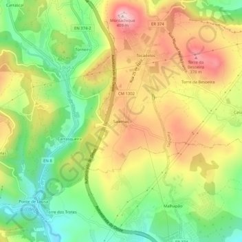
Name: Salemas topographic map, elevation, terrain.
Location: Salemas, Lousa, Loures, Lisboa, 2660-101, Portugal (38.86086 -9.21441 38.90086 -9.17441)
Average elevation: 774 ft
Minimum elevation: 299 ft
Maximum elevation: 1,309 ft
Thank you for supporting this site ❤️
Make a donation
Make a donation
Gear up for your next adventure:
As an Amazon Associate, this site earns from qualifying purchases at no extra cost to you.
Other topographic maps
Click on a map to view its topography, its elevation and its terrain.
Cabeço de Montachique
Portugal > Lisboa > Loures > Lousa > Cabeço de Montachique
Average elevation: 833 ft