
Dottel topographic map
Click on the map to display elevation.
Dottel
Dottel liegt östlich von Kall an einem nach Süden ansteigenden Höhenzug (Weyerer Wald). Weitere angrenzende Ortsteile/Gemeinden sind
About this map
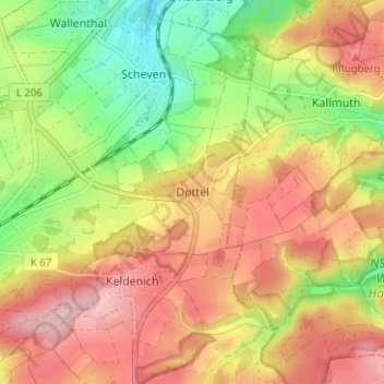
Name: Dottel topographic map, elevation, terrain.
Average elevation: 1,427 ft
Minimum elevation: 1,102 ft
Maximum elevation: 1,716 ft
Other topographic maps
Click on a map to view its topography, its elevation and its terrain.
Sistiger Heide
Deutschland > Nordrhein-Westfalen > Kreis Euskirchen > Kall > Benenberg
Average elevation: 1,870 ft