Geolocate

Yampa topographic map

Click on the map to display elevation.

Yampa

Yampa has a humid continental climate (Köppen climate classification Dfb), with warm summers and long, cold, snowy winters. Due to altitude and dryness, the diurnal temperature variation is large throughout the year, especially in summer, and the growing season is short, typically averaging just 80 days.

Wikipedia (CC-BY-SA 3.0)

About this map

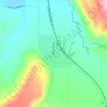
Name: Yampa topographic map, elevation, terrain.

Location: Yampa, Routt County, Colorado, 80483, United States (40.14858 -106.91332 40.15776 -106.90203)

Average elevation: 7,946 ft

Minimum elevation: 7,749 ft

Maximum elevation: 8,406 ft

Routt County trails, hiking, mountain biking, running and outdoor activities

Other topographic maps

Click on a map to view its topography, its elevation and its terrain.

Pagoda

United States > Colorado > Routt County

Average elevation: 6,850 ft

Oak Creek

United States > Colorado > Routt County

Average elevation: 7,628 ft

Hahns Peak

United States > Colorado > Routt County

Average elevation: 9,482 ft

Steamboat Lake

United States > Colorado > Routt County

Average elevation: 8,084 ft

Sugar Loaf Mountain

United States > Colorado > Routt County

Average elevation: 9,186 ft

Gore Mountain

United States > Colorado > Routt County

Average elevation: 10,180 ft

Gear up for your next adventure:

🛠️Outdoor Gear Repair Kit - Essential tools to fix gear on the trail
🎒Waterproof Dry Bags - Keep your electronics and maps dry inside your pack
🗺️Topographic Maps - Detailed topo maps for hiking, exploring and outdoor navigation
🪶Thermal Camp Blanket - Extra warmth for cold nights
🦺Reflective Outdoor Gear - Safety gear for low‑light conditions

As an Amazon Associate, this site earns from qualifying purchases at no extra cost to you.