Geolocate

Benenberg topographic map

Click on the map to display elevation.

About this map

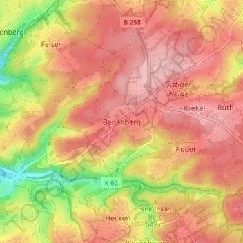
Name: Benenberg topographic map, elevation, terrain.

Location: Benenberg, Kall, Kreis Euskirchen, Nordrhein-Westfalen, Deutschland (50.44920 6.49437 50.48920 6.53437)

Average elevation: 1,801 ft

Minimum elevation: 1,467 ft

Maximum elevation: 1,988 ft

Other topographic maps

Click on a map to view its topography, its elevation and its terrain.

Gear up for your next adventure:

🪶Compact Camp Shovel - Folding shovel for campsite tasks
🖼️Topo Map Wall Art - Decorative topographic prints of famous peaks and regions
🔌USB Car Charger - Car charger for on‑the‑go power needs
🥾Women's Hiking Boots - Top-rated trail boots with ankle support and superior grip
🔭Stargazing Telescopes - Perfect for camping in low-light pollution areas shown on maps

As an Amazon Associate, this site earns from qualifying purchases at no extra cost to you.