Geolocate

Gaisthal topographic map

Click on the map to display elevation.

Gaisthal

Gaisthal liegt an der Nordwestseite des Frauensteins am Fluss Ascha. Die Hauptstraßen des Ortes sind die Staatsstraßen 2159 und 2152. Schönsee liegt rund 4,7 Kilometer Luftlinie entfernt. Gaisthal liegt auf einer Höhe von rund 530 m ü. NN.

Wikipedia (CC-BY-SA 3.0)

About this map

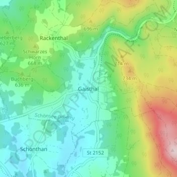
Name: Gaisthal topographic map, elevation, terrain.

Location: Gaisthal, Schönsee, Schönsee (VGem), Landkreis Schwandorf, Bayern, 92539, Deutschland (49.45940 12.48285 49.49940 12.52285)

Average elevation: 2,031 ft

Minimum elevation: 1,683 ft

Maximum elevation: 2,841 ft

Gear up for your next adventure:

🗺️NatGeo Topo Maps - High-quality waterproof printed topographic maps of US Parks
Camping Coffee Makers - Enjoy premium coffee at the summit or campsite
🦶Hiking Gaiters - Keep debris and water out of your boots
🔦Compact Flashlight - Reliable flashlight for emergencies
Solar GPS Watches - Advanced multisport watches with built-in topographic maps

As an Amazon Associate, this site earns from qualifying purchases at no extra cost to you.