
Make a donation
Gear up for your next adventure:
As an Amazon Associate, this site earns from qualifying purchases at no extra cost to you.
South Governorate topographic map
Click on the map to display elevation.
Make a donation
Gear up for your next adventure:
As an Amazon Associate, this site earns from qualifying purchases at no extra cost to you.
South Governorate
South Governorate (Arabic: محافظة الجنوب, romanized: muḥāfaẓat al-Janūb, or simply الجنوب) is one of the governorates of Lebanon, with a population of 590,000 inhabitants and an area of 929.6 km2. The capital is Sidon. The lowest elevation is sea-level; the highest is 1,000 meters. The local population is religiously diverse and includes Shia and Sunni Muslims, Druze, Eastern Orthodox, Maronite, Protestant, and Greek Catholic Christians. Temperatures can drop to 4 °C during winter with much rain and snow on the higher ground. In the humid summer, temperatures can rise to 30 °C in the coastal areas. The governorate has several rivers: the Litani, Deir El Zahrani, Naqoura, Awali, Qasmiye, and Hasbani. The area is famous for its citrus and banana farms. Its main cities are Sidon, Tyre and Jezzine.
Make a donation
Gear up for your next adventure:
As an Amazon Associate, this site earns from qualifying purchases at no extra cost to you.
About this map
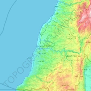
Name: South Governorate topographic map, elevation, terrain.
Location: South Governorate, Lebanon (33.08543 35.10356 33.59201 35.63822)
Average elevation: 820 ft
Minimum elevation: -3 ft
Maximum elevation: 4,754 ft
Make a donation
Gear up for your next adventure:
As an Amazon Associate, this site earns from qualifying purchases at no extra cost to you.
Other topographic maps
Click on a map to view its topography, its elevation and its terrain.
Make a donation
Gear up for your next adventure:
As an Amazon Associate, this site earns from qualifying purchases at no extra cost to you.
Beirut
The average annual rainfall is 825 millimetres (32.5 in), with the large majority of it falling from October to April. Much of the autumn and spring rain falls in heavy downpours on a limited number of days, but in winter it is spread more evenly over many days. Summer receives very little rainfall, if any.…
Average elevation: 476 ft
Make a donation
Gear up for your next adventure:
As an Amazon Associate, this site earns from qualifying purchases at no extra cost to you.
Make a donation
Gear up for your next adventure:
As an Amazon Associate, this site earns from qualifying purchases at no extra cost to you.
Beit Mery
Lebanon > Mount Lebanon Governorate
1) Beit Mery I is on the right bank of the Beirut River, south southwest of the town at an altitude of approximately 125 metres (410 ft) above sea level. It was found by Jesuit Father Dillenseger who determined it to be an Acheulean site. The material was donated to the Saint Joseph University by the French…
Average elevation: 1,339 ft
Kfar Nabrakh
Lebanon > Mount Lebanon Governorate
Kfar Nabrakh (Arabic: كفر نبرخ Kfar Nabrakh) is a municipality in the Chouf District of Mount Lebanon Governorate, Lebanon. It is located 50 kilometers southeast of Beirut. Kfarnabrakh total land area consists of 941 hectares. Its average elevation is 1,010 meters above sea level. Its inhabitants are…
Average elevation: 3,048 ft
Make a donation
Gear up for your next adventure:
As an Amazon Associate, this site earns from qualifying purchases at no extra cost to you.
Aramoun
Lebanon > Mount Lebanon Governorate
Aramoun (Arabic: عرمون) is a village in the Aley District of Mount Lebanon, Lebanon, lying to the east of Khalde and 22 kilometres away from Beirut. Aramoun's altitude ranges between 250 meters to 600 meters further east. The village has a Druze and Christian community, major families are Yehia, Jawhari,…
Average elevation: 1,532 ft
Make a donation
Gear up for your next adventure:
As an Amazon Associate, this site earns from qualifying purchases at no extra cost to you.
Mazraat Al Shouf
Lebanon > Mount Lebanon Governorate
Mazraat el-Chouf (Arabic: مزرعة الشوف; also spelled Mazra'at al-Shuf) is a municipality in the Chouf District of the Mount Lebanon Governorate in Lebanon. It is located 50 kilometers southeast of Beirut. Its average elevation is 950 meters above sea level and its total land area is 1,359 hectares.…
Average elevation: 2,802 ft
Make a donation
Gear up for your next adventure:
As an Amazon Associate, this site earns from qualifying purchases at no extra cost to you.
Hazmieh
Lebanon > Mount Lebanon Governorate
Hazmieh covers an area of 2.73 square kilometers directly southeast of Beirut, at an elevation of between 50–200 meters above sea level. Its borders are defined by the Beirut River and Sin El Fil Boulevard to the north, Camille Chamoun Boulevard to the west, by El Sayad Roundabout and Rihaniyya Junction to…
Average elevation: 387 ft
Make a donation
Gear up for your next adventure:
As an Amazon Associate, this site earns from qualifying purchases at no extra cost to you.
Bikfaya
Lebanon > Mount Lebanon Governorate
Bikfaya is nestled in the mountains overlooking the Mediterranean with an elevation ranging from 900 to 1000 meters above sea level. It lies 25 km from Beirut and only a short drive to the Mzaar-Kfardebian ski resort and Zaarour Club. Summers in Bikfaya are cool and characterized by periods of fog in the…
Average elevation: 2,766 ft
Aaqoura
Lebanon > Keserwan-Jbeil Governorate
Aqoura (Arabic: عاقورة, also spelled Aaqoura, "Akoura") is a mountainous village in the Byblos District of Keserwan-Jbeil Governorate, Lebanon. It is lovated 68 kilometers north of Beirut. Aaqoura has an average elevation of 1,600 meters above sea level (between 1000 and 2189 m) and a total land area of…
Average elevation: 5,217 ft
Make a donation
Gear up for your next adventure:
As an Amazon Associate, this site earns from qualifying purchases at no extra cost to you.
Bsharri
Bsharri (Arabic: بشرّي Bšarrī; also romanized Becharre, Bcharre, Bsharre, Bcharre Al Arz) is a Lebanese town located in the district of the same name, North Governorate, situated at altitudes between 1,100 m (3,600 ft) and 3,088 m (10,131 ft). Bsharri is the location of the Cedars of God, a UNESCO World…
Average elevation: 6,060 ft
Make a donation
Gear up for your next adventure:
As an Amazon Associate, this site earns from qualifying purchases at no extra cost to you.
Mount Lebanon
Mount Lebanon (Arabic: جَبَل لُبْنَان, jabal lubnān, Levantine Arabic pronunciation: [ˈʒabal lɪbˈneːn]; Syriac: ܛܘܪ ܠܒ݂ܢܢ, ṭūr leḇnān, Syriac pronunciation: [tˤur lewˈnɔn], ṭūr lewnōn) is a mountain range in Lebanon. It averages above 2,500 m (8,200 ft) in elevation,…
Average elevation: 9,249 ft
Qaraoun
The development activity near the village, consequent to land area the Qaraoun village transferred for building of the El Qaraoun Dam in the middle reaches of the Litani River, which created an artificial lake (33°34′11.63″N 35°41′51.18″E / 33.5698972°N 35.6975500°E / 33.5698972;…
Average elevation: 3,369 ft
Make a donation
Gear up for your next adventure:
As an Amazon Associate, this site earns from qualifying purchases at no extra cost to you.
Make a donation
Gear up for your next adventure:
As an Amazon Associate, this site earns from qualifying purchases at no extra cost to you.
Lehfed
Lebanon > Keserwan-Jbeil Governorate
Lehfed (Arabic: لحفد, also known as Lihfid) is a municipality in the Byblos District of Keserwan-Jbeil Governorate, Lebanon. It is 55 kilometers north of Beirut. Lehfed has an average elevation of 1000 meters above sea level and a total land area of 542 hectares. There were three companies with more than…
Average elevation: 3,442 ft
Make a donation
Gear up for your next adventure:
As an Amazon Associate, this site earns from qualifying purchases at no extra cost to you.
Make a donation
Gear up for your next adventure:
As an Amazon Associate, this site earns from qualifying purchases at no extra cost to you.
Make a donation
Gear up for your next adventure:
As an Amazon Associate, this site earns from qualifying purchases at no extra cost to you.
Make a donation
Gear up for your next adventure:
As an Amazon Associate, this site earns from qualifying purchases at no extra cost to you.
Abey
Lebanon > Mount Lebanon Governorate
Aabey, also spelled Abey (Arabic: عبيه), is a village located in Mount Lebanon, in Aley District of Mount Lebanon Governorate. It is located 22 km (14 mi) from Beirut and has an altitude of 800 m (2,600 feet). It is bordered by Kfarmatta (South), Al Bennay (East), Damour (West), and Ain Ksour (North). It…
Average elevation: 1,893 ft
Make a donation
Gear up for your next adventure:
As an Amazon Associate, this site earns from qualifying purchases at no extra cost to you.
Deir Al Qamar
Lebanon > Mount Lebanon Governorate
Deir al-Qamar (Arabic: دَيْر الْقَمَر, romanized: Dayr al-qamar, lit. 'Monastery of the moon') is a city south-east of Beirut in south-central Lebanon. It is located five kilometres outside of Beit ed-Dine in the Chouf District of the Mount Lebanon Governorate at 800 m of average altitude.
Average elevation: 2,457 ft
Sawfar
Lebanon > Mount Lebanon Governorate
Ru’ Aysat Sawfar or Sawfar (Arabic: رويسات صوفر or صوفر, French: Rue’ Aysat Sawfar), Sawfar, Saoufar or Sofar) is a village in the Aley District of the Mount Lebanon Governorate in Lebanon. Perched at an elevation of more than 1,433 metres (4,701 feet), Sawfar lies adjacent to the main road…
Average elevation: 3,796 ft
Make a donation
Gear up for your next adventure:
As an Amazon Associate, this site earns from qualifying purchases at no extra cost to you.
Make a donation
Gear up for your next adventure:
As an Amazon Associate, this site earns from qualifying purchases at no extra cost to you.
Make a donation
Gear up for your next adventure:
As an Amazon Associate, this site earns from qualifying purchases at no extra cost to you.
Mount Lebanon
Mount Lebanon (Arabic: جبل لبنان, romanized: Jabal Lubnān; Syriac: ܛܘܪ ܠܒܢܢ, romanized: Tur Lebnon) is a mountain range in Lebanon. It is about 170 km (110 mi) long and averages above 2,500 m (8,200 ft) in elevation, with its peak at 3,088 m (10,131 ft). The range provides a typical alpine climate year-round.
Average elevation: 9,249 ft
Make a donation
Gear up for your next adventure:
As an Amazon Associate, this site earns from qualifying purchases at no extra cost to you.
Zahle
Zahlé is located 55 km (34 mi) east of the capital Beirut, close to the Beirut-Damascus road, and lies at the junction of Mount Lebanon and the Beqaa Valley, at a mean elevation of 1,000 m. Established in the 18th century by Christians, Zahlé maintains its predominantly Greek Catholic character. The city has…
Average elevation: 4,203 ft
Meiss Ej Jabal
Lebanon > Nabatieh Governorate
The municipality of Mais al-Jabal is located in the Marjayoun District, one of the eight mohafazats (governorates) of Lebanon. Mais al-Jabal is 114 kilometers (70.8396 mi) away from Beyrouth (Beirut) the capital of Lebanon. Its elevation is 630 meters (2067.03 ft - 688.968 yd) above sea level. Mais al-Jabal…
Average elevation: 1,808 ft
Make a donation
Gear up for your next adventure:
As an Amazon Associate, this site earns from qualifying purchases at no extra cost to you.
Faraya
Lebanon > Keserwan-Jbeil Governorate
Faraya (Arabic: فاريا) is a village and municipality in the Keserwan District of the Keserwan-Jbeil Governorate, Lebanon. It is located 46 kilometers north of Beirut. Elevation start from 1290 meters to 2000 meters above sea level and its total land area is 870 hectares. Faraya's inhabitants are…
Average elevation: 5,112 ft
Antelias
Lebanon > Mount Lebanon Governorate
The municipality of Antelias - Naqqach is located in the Kaza of Metn in Mount Lebanon, one of the eight mohafazats (governorates) of Lebanon. Antelias - Naqqach is 8 kilometers (4.9712 mi) from Beyrouth (Beirut), the capital of Lebanon. Its elevation is 10 meters (32.81 ft; 10.936 yd) above sea level.…
Average elevation: 614 ft
Make a donation
Gear up for your next adventure:
As an Amazon Associate, this site earns from qualifying purchases at no extra cost to you.
Kafr Bayt
Kfar Beit (also known as كفر بيت, Kfar Beït, Kafr Bayt or Kfarbeet) is a Lebanese village in the south of Lebanon. It is close to the city of Saida. Kfar Beit has an average elevation of 374 meters or 1,227 feet.
Average elevation: 1,217 ft
Ehmej
Lebanon > Keserwan-Jbeil Governorate
Ehmej has a total land area of 1,742 hectares. The town's average elevation is 1,140 meters above sea level. Neighboring municipalities include Mish Mish to the west, Jaj to the north, Laqlouq and Mazraat es-Siyad to the east and Almat el-Shemaliat and Almat al-Janubiat to the south.
Average elevation: 3,947 ft
Make a donation
Gear up for your next adventure:
As an Amazon Associate, this site earns from qualifying purchases at no extra cost to you.
Aynata
Lebanon > Nabatieh Governorate
Israeli archaeologist Yohanan Aharoni identified Aynata as ancient En-hazor, and says it appears in the topographical lists of Thutmose III.
Average elevation: 2,470 ft
Make a donation
Gear up for your next adventure:
As an Amazon Associate, this site earns from qualifying purchases at no extra cost to you.
Baadaran
Lebanon > Mount Lebanon Governorate
Baadarâne (Arabic: بعدران Baʿdarān), is an area in Chouf, Mont Liban, Lebanon. Baadarane is 60 kilometres (37 mi) away from Beirut at an elevation of 1,050 meters .
Average elevation: 3,018 ft
Bdebba
The town of Bdebba is located in the Qada’a of Koura in the North governorate at an average altitude of 900 feet (270 meters) above sea level. Bdebba is 45 miles (72 kilometers) north of Beirut 3.5 miles (5.6 kilometers) east of the Mediterranean sea and 6 miles (9.7 kilometers) south of Tripoli (Trablous)…
Average elevation: 928 ft
Make a donation
Gear up for your next adventure:
As an Amazon Associate, this site earns from qualifying purchases at no extra cost to you.