
Thank you for supporting this site ❤️
Make a donation
Make a donation
Gear up for your next adventure:
As an Amazon Associate, this site earns from qualifying purchases at no extra cost to you.
Dubberly topographic map
Click on the map to display elevation.
Thank you for supporting this site ❤️
Make a donation
Make a donation
Gear up for your next adventure:
As an Amazon Associate, this site earns from qualifying purchases at no extra cost to you.
About this map
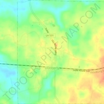
Name: Dubberly topographic map, elevation, terrain.
Location: Dubberly, Webster Parish, Louisiana, United States (32.52649 -93.25417 32.55620 -93.22044)
Average elevation: 246 ft
Minimum elevation: 177 ft
Maximum elevation: 315 ft
Webster Parish trails, hiking, mountain biking, running and outdoor activities
Thank you for supporting this site ❤️
Make a donation
Make a donation
Gear up for your next adventure:
As an Amazon Associate, this site earns from qualifying purchases at no extra cost to you.
Other topographic maps
Click on a map to view its topography, its elevation and its terrain.
Caney Lakes Unit (Kisatchie National Forest)
United States > Louisiana > Webster Parish
Average elevation: 262 ft