Geolocate

Waldkirchen topographic map

Click on the map to display elevation.

About this map

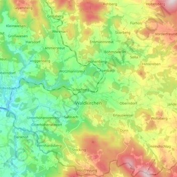
Name: Waldkirchen topographic map, elevation, terrain.

Location: Waldkirchen, Landkreis Freyung-Grafenau, Bavaria, 94065, Germany (48.68205 13.54335 48.79631 13.67472)

Average elevation: 1,965 ft

Minimum elevation: 1,266 ft

Maximum elevation: 3,159 ft

Other topographic maps

Click on a map to view its topography, its elevation and its terrain.

Kumreut

Germany > Bavaria > Landkreis Freyung-Grafenau

Average elevation: 1,719 ft

Altbachhaus

Germany > Bavaria > Landkreis Freyung-Grafenau > Grafenau > Schlag

Average elevation: 2,044 ft

Gear up for your next adventure:

🔌USB Car Charger - Car charger for on‑the‑go power needs
🪶Paracord Bracelet - Survival bracelet with built‑in tools
🥾Men's Hiking Boots - Durable, waterproof footwear for rugged terrain and steep inclines
📚USA Hiking Guide Books - Top trail guides and map books
🗺️Topographic Maps - Detailed topo maps for hiking, exploring and outdoor navigation

As an Amazon Associate, this site earns from qualifying purchases at no extra cost to you.