
Make a donation
Gear up for your next adventure:
As an Amazon Associate, this site earns from qualifying purchases at no extra cost to you.
Neumünster topographic map
Click on the map to display elevation.
Make a donation
Gear up for your next adventure:
As an Amazon Associate, this site earns from qualifying purchases at no extra cost to you.
Neumünster
1871 wurde die Holstenschule als Privatschule für Jungen aus dem höheren Bürgerstand gegründet. Auch die Gründung der Privaten Höheren Mädchenschule, die heute Klaus-Groth-Schule Neumünster heißt und seit 1925 staatlich ist, fiel in diese Zeit.
Make a donation
Gear up for your next adventure:
As an Amazon Associate, this site earns from qualifying purchases at no extra cost to you.
About this map
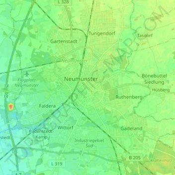
Name: Neumünster topographic map, elevation, terrain.
Location: Neumünster, Schleswig-Holstein, 24534, Deutschland (54.03574 9.94154 54.11574 10.02154)
Average elevation: 82 ft
Minimum elevation: 36 ft
Maximum elevation: 164 ft
Make a donation
Gear up for your next adventure:
As an Amazon Associate, this site earns from qualifying purchases at no extra cost to you.
Other topographic maps
Click on a map to view its topography, its elevation and its terrain.