
Thank you for supporting this site ❤️
Make a donation
Make a donation
Gear up for your next adventure:
As an Amazon Associate, this site earns from qualifying purchases at no extra cost to you.
Alpalhão topographic map
Click on the map to display elevation.
Thank you for supporting this site ❤️
Make a donation
Make a donation
Gear up for your next adventure:
As an Amazon Associate, this site earns from qualifying purchases at no extra cost to you.
About this map
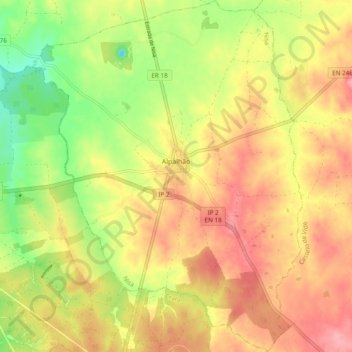
Name: Alpalhão topographic map, elevation, terrain.
Location: Alpalhão, Nisa, Portalegre, Portugal (39.37724 -7.65893 39.45166 -7.58499)
Average elevation: 1,043 ft
Minimum elevation: 860 ft
Maximum elevation: 1,184 ft
Thank you for supporting this site ❤️
Make a donation
Make a donation
Gear up for your next adventure:
As an Amazon Associate, this site earns from qualifying purchases at no extra cost to you.
Other topographic maps
Click on a map to view its topography, its elevation and its terrain.
Câmara de Carga do Aproveitamento Hidroeléctrico de Bruceira
Portugal > Portalegre > Nisa
Average elevation: 846 ft