
Make a donation
Gear up for your next adventure:
As an Amazon Associate, this site earns from qualifying purchases at no extra cost to you.
Vittoria topographic map
Click on the map to display elevation.
Make a donation
Gear up for your next adventure:
As an Amazon Associate, this site earns from qualifying purchases at no extra cost to you.
Vittoria
The town was founded on a very fertile valley known as "Boscopiano". On the south of the city there is the "natural reserve of Aleppo pines" (Riserva naturale del Pino d'Aleppo). The coastlines along the sea are low and sandy with rare rocks. The highest point, though poorly mountainous, is Mount Calvo (250 meters). Vittoria is located between the municipalities of Acate and Ragusa, while the hillside is bordered by the towns of Comiso and Chiaramonte Gulfi. It is located 27 km from Ragusa and Gela, 108 km from Siracusa and 131 km from Catania. Vittoria has an altitude of 168 meters s.l.m. and an area of 181.31 km². Its only hamlet (frazione) is the seaside locality of Scoglitti. However, in addition to the urban area, it has 45 different contrade.
Make a donation
Gear up for your next adventure:
As an Amazon Associate, this site earns from qualifying purchases at no extra cost to you.
About this map
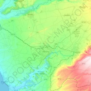
Name: Vittoria topographic map, elevation, terrain.
Location: Vittoria, Ragusa, Sicily, 97019, Italy (36.87376 14.38772 37.05345 14.59738)
Average elevation: 636 ft
Minimum elevation: 0 ft
Maximum elevation: 2,028 ft
Make a donation
Gear up for your next adventure:
As an Amazon Associate, this site earns from qualifying purchases at no extra cost to you.