
Alzey topographic map
Interactive map
Click on the map to display elevation.
About this map
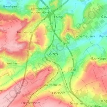
Name: Alzey topographic map, elevation, terrain.
Location: Alzey, Landkreis Alzey-Worms, Rijnland-Palts, Duitsland (49.71895 8.04044 49.77237 8.16632)
Average elevation: 728 ft
Minimum elevation: 489 ft
Maximum elevation: 1,007 ft
Other topographic maps
Click on a map to view its topography, its elevation and its terrain.
Wachenheim
Duitsland > Rijnland-Palts > Landkreis Alzey-Worms
Wachenheim, Monsheim, Landkreis Alzey-Worms, Rijnland-Palts, Duitsland
Average elevation: 676 ft
Flonheim
Duitsland > Rijnland-Palts > Landkreis Alzey-Worms > Flonheim
Flonheim, Alzey-Land, Landkreis Alzey-Worms, Rijnland-Palts, Duitsland
Average elevation: 568 ft