Geolocate

Grand Rapids topographic map

Click on the map to display elevation.

About this map

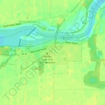
Name: Grand Rapids topographic map, elevation, terrain.

Location: Grand Rapids, Wood County, Ohio, United States (41.40447 -83.87703 41.41642 -83.85433)

Average elevation: 659 ft

Minimum elevation: 623 ft

Maximum elevation: 679 ft

Wood County trails, hiking, mountain biking, running and outdoor activities

Other topographic maps

Click on a map to view its topography, its elevation and its terrain.

Cedar Creek Woods

United States > Ohio > Wood County > Northwood

Average elevation: 607 ft

Westgate Homes

United States > Ohio > Wood County > Bowling Green

Average elevation: 689 ft

Perry Center

United States > Ohio > Wood County

Average elevation: 732 ft

Dowling

United States > Ohio > Wood County

Average elevation: 656 ft

Gear up for your next adventure:

⛑️Personal Locator Beacon - Safety beacon for emergencies
🧢Sun Protection Hats - Wide-brimmed and UPF-rated hats for high-altitude sun safety
🏔️Mountain Trail Maps - High‑detail maps for popular peaks
🧭Outdoor Navigation Book - Learn advanced navigation skills
🩹Survival Bandages - High‑quality bandages for emergencies

As an Amazon Associate, this site earns from qualifying purchases at no extra cost to you.