Geolocate

Legburthwaite topographic map

Click on the map to display elevation.

About this map

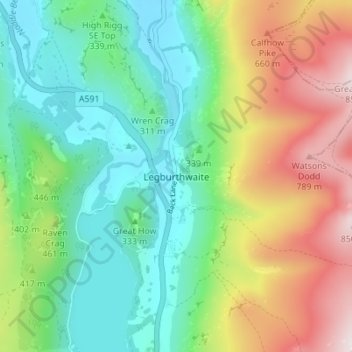
Name: Legburthwaite topographic map, elevation, terrain.

Location: Legburthwaite, Cumberland, England, CA12 4TQ, United Kingdom (54.54462 -3.07499 54.58462 -3.03499)

Average elevation: 1,286 ft

Minimum elevation: 479 ft

Maximum elevation: 2,808 ft

Other topographic maps

Click on a map to view its topography, its elevation and its terrain.

Arthuret

United Kingdom > England > Cumberland

Average elevation: 171 ft

Emerald Pools

United Kingdom > England > Cumberland

Average elevation: 1,716 ft

Penrith

United Kingdom > England > Cumberland

Average elevation: 531 ft

Whitehaven

United Kingdom > England > Cumberland

Average elevation: 194 ft

Gear up for your next adventure:

🧯Emergency Survival Kit - All‑in‑one survival essentials for the backcountry
🥾Hiking Shoes - Durable and comfortable shoes for trail hiking
📱Heavy-Duty Phone Cases - Drop-proof and waterproof protection for outdoor navigation
Backpacking Tent - Lightweight and durable tent for multi‑day hikes
🚗GPS Dash Cams - Record your scenic drives through mountain passes and canyons

As an Amazon Associate, this site earns from qualifying purchases at no extra cost to you.