Geolocate

Penrith topographic map

Click on the map to display elevation.

About this map

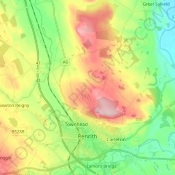
Name: Penrith topographic map, elevation, terrain.

Location: Penrith, Cumberland, England, United Kingdom (54.64616 -2.79696 54.72604 -2.70703)

Average elevation: 531 ft

Minimum elevation: 249 ft

Maximum elevation: 922 ft

Other topographic maps

Click on a map to view its topography, its elevation and its terrain.

Braithwaite

United Kingdom > England > Cumberland

Average elevation: 577 ft

Cat Bells

United Kingdom > England > Cumberland > Stair

Average elevation: 597 ft

The Green

United Kingdom > England > Cumberland

Average elevation: 210 ft

Drumburgh

United Kingdom > England > Cumberland

Average elevation: 20 ft

Legburthwaite

United Kingdom > England > Cumberland

Average elevation: 1,286 ft

Bridgefoot

United Kingdom > England > Cumberland

Average elevation: 213 ft

Gear up for your next adventure:

🧭Orienteering Set - Complete compass and map reading kit
🧦Hiking Socks - Comfortable socks to prevent blisters on long hikes
🎒Gear Packing Cubes - Organize your backpack efficiently
🧤Hiking Gloves - Protective gloves for rugged trails
⛑️Personal Locator Beacon - Safety beacon for emergencies

As an Amazon Associate, this site earns from qualifying purchases at no extra cost to you.