
Thank you for supporting this site ❤️
Make a donation
Make a donation
Gear up for your next adventure:
As an Amazon Associate, this site earns from qualifying purchases at no extra cost to you.
Vermicino topographic map
Click on the map to display elevation.
Thank you for supporting this site ❤️
Make a donation
Make a donation
Gear up for your next adventure:
As an Amazon Associate, this site earns from qualifying purchases at no extra cost to you.
About this map
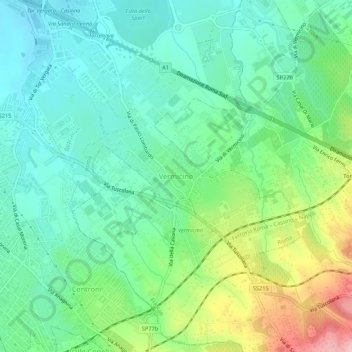
Name: Vermicino topographic map, elevation, terrain.
Location: Vermicino, Roma, Lazio, 00118, Italia (41.80522 12.62190 41.84522 12.66190)
Average elevation: 423 ft
Minimum elevation: 233 ft
Maximum elevation: 883 ft
Thank you for supporting this site ❤️
Make a donation
Make a donation
Gear up for your next adventure:
As an Amazon Associate, this site earns from qualifying purchases at no extra cost to you.
Other topographic maps
Click on a map to view its topography, its elevation and its terrain.
Monumento Naturale di Galeria Antica
Italia > Lazio > Roma > Roma > Osteria Nuova > Santa Maria di Galeria
Average elevation: 397 ft