Geolocate

Gattinara topographic map

Click on the map to display elevation.

About this map

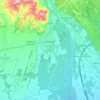
Name: Gattinara topographic map, elevation, terrain.

Location: Gattinara, Vercelli, Piedmont, 13045, Italy (45.57111 8.31920 45.64510 8.39436)

Average elevation: 925 ft

Minimum elevation: 728 ft

Maximum elevation: 1,732 ft

Other topographic maps

Click on a map to view its topography, its elevation and its terrain.

Foresto

Italy > Piedmont > Vercelli > Borgosesia

Average elevation: 2,123 ft

Sn2

Italy > Piedmont > Vercelli > Boccioleto

Average elevation: 4,232 ft

Ruse

Italy > Piedmont > Vercelli > Varallo > I Prati

Average elevation: 2,582 ft

Fontana dello Zolfo

Italy > Piedmont > Vercelli > Trino

Average elevation: 489 ft

Le Castelle

Italy > Piedmont > Vercelli > Gattinara

Average elevation: 1,030 ft

San Giuseppe

Italy > Piedmont > Vercelli

Average elevation: 5,308 ft

Sasso Lungo

Italy > Piedmont > Vercelli > Scopa > Otra

Average elevation: 2,802 ft

Montata

Italy > Piedmont > Vercelli > Varallo

Average elevation: 3,993 ft

Gear up for your next adventure:

Solar GPS Watches - Advanced multisport watches with built-in topographic maps
🛌Ultralight Sleeping Bags - Compact down bags for cold nights in the wilderness
📦Gear Storage Bags - Organize and protect outdoor equipment
🔦LED Headlamp - Bright and durable LED headlamp for night navigation
🥄Camping Utensil Set - Lightweight utensils for outdoor meals

As an Amazon Associate, this site earns from qualifying purchases at no extra cost to you.