
Make a donation
Gear up for your next adventure:
As an Amazon Associate, this site earns from qualifying purchases at no extra cost to you.
San Giuseppe topographic map
Click on the map to display elevation.
Make a donation
Gear up for your next adventure:
As an Amazon Associate, this site earns from qualifying purchases at no extra cost to you.
About this map
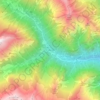
Name: San Giuseppe topographic map, elevation, terrain.
Location: San Giuseppe, Alto Sermenza, Vercelli, Piedmont, 13029, Italy (45.84534 8.00374 45.88534 8.04374)
Average elevation: 5,308 ft
Minimum elevation: 3,110 ft
Maximum elevation: 7,825 ft
Make a donation
Gear up for your next adventure:
As an Amazon Associate, this site earns from qualifying purchases at no extra cost to you.
Other topographic maps
Click on a map to view its topography, its elevation and its terrain.
Alagna Valsesia
Alagna Valsesia (Walser German: Im Land, Piedmontese: Alagna, Valsesiano: Lagna) is a comune and small village high in the Valsesia alpine valley in the province of Vercelli, Piedmont, northern Italy, a UNESCO World heritage site since 2013. It is a tourist place for mountaineering and winter sports, and it is…
Average elevation: 6,795 ft
Make a donation
Gear up for your next adventure:
As an Amazon Associate, this site earns from qualifying purchases at no extra cost to you.
Scopello
Scopello is a comune (municipality) located in the Valsesia region of the Italian Pennine Alps, administratively in the Province of Vercelli, Piedmont. The municipality covers an area of 18.62 square kilometres (7.19 sq mi) and ranges in elevation from 640 to 1,930 metres (2,100 to 6,330 ft) above sea level.…
Average elevation: 4,121 ft
Make a donation
Gear up for your next adventure:
As an Amazon Associate, this site earns from qualifying purchases at no extra cost to you.