
Thank you for supporting this site ❤️
Make a donation
Make a donation
Gear up for your next adventure:
As an Amazon Associate, this site earns from qualifying purchases at no extra cost to you.
Mukina topographic map
Click on the map to display elevation.
Thank you for supporting this site ❤️
Make a donation
Make a donation
Gear up for your next adventure:
As an Amazon Associate, this site earns from qualifying purchases at no extra cost to you.
About this map
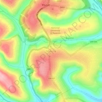
Name: Mukina topographic map, elevation, terrain.
Location: Mukina, Tumba, Huye, Southern Province, Rwanda (-2.64353 29.72223 -2.60353 29.76223)
Average elevation: 5,571 ft
Minimum elevation: 5,295 ft
Maximum elevation: 5,853 ft
Thank you for supporting this site ❤️
Make a donation
Make a donation
Gear up for your next adventure:
As an Amazon Associate, this site earns from qualifying purchases at no extra cost to you.