
Santa Croce topographic map
Click on the map to display elevation.
About this map
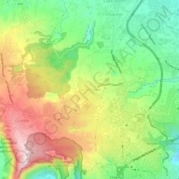
Name: Santa Croce topographic map, elevation, terrain.
Location: Santa Croce, Naples, Campania, 80131, Italy (40.85368 14.19120 40.89368 14.23120)
Average elevation: 823 ft
Minimum elevation: 276 ft
Maximum elevation: 1,499 ft
Other topographic maps
Click on a map to view its topography, its elevation and its terrain.