Geolocate

Kiso topographic map

Click on the map to display elevation.

About this map

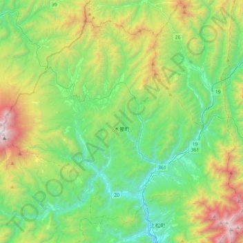
Name: Kiso topographic map, elevation, terrain.

Location: Kiso, Kiso District, Nagano Prefecture, Japan (35.78904 137.47617 36.02680 137.82829)

Average elevation: 4,469 ft

Minimum elevation: 2,201 ft

Maximum elevation: 9,619 ft

Other topographic maps

Click on a map to view its topography, its elevation and its terrain.

Mt. Ontake

Japan > Kiso District > Otaki

Average elevation: 8,773 ft

Mt. Ontake

Japan > Kiso District > Otaki

Average elevation: 8,773 ft

Gear up for your next adventure:

🚑Emergency Bivvies - Heat-reflective sleeping bags for survival situations
👟Men's Trail Runners - Lightweight footwear for fast-paced exploration and light hiking
🧯Emergency Survival Kit - All‑in‑one survival essentials for the backcountry
🧴Hand Sanitizer - Keep hands clean while hiking
📻Weather Alert Radios - Stay informed of storm risks while off-the-grid

As an Amazon Associate, this site earns from qualifying purchases at no extra cost to you.